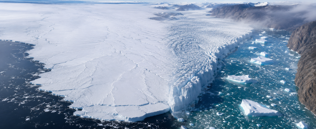
Thwaites Glacier and Jakobshavn Glacier, also known as Sermeq Kujalleq, are often placed in the same climate debate because both are fast outlet glaciers losing ice to the ocean. Their place logic is not the same. Thwaites is a remote Antarctic ice system on the Amundsen Sea, without settlement, tourism infrastructure or local civic management. Jakobshavn is a Greenland tidewater glacier flowing through Ilulissat Icefjord beside a town, a harbour, visitor routes and a UNESCO-listed landscape.
Location and spatial form
Thwaites lies in West Antarctica, in Marie Byrd Land, where ice drains toward the Amundsen Sea. Its basin covers about 192,000 km², roughly the size of Florida or Great Britain, and much of the glacier rests on bedrock below sea level. Reaching it requires ships, aircraft, temporary camps and polar expedition logistics. Jakobshavn sits on Greenland’s west coast, about 250 km north of the Arctic Circle, where the glacier reaches Disko Bay through Kangia, the Ilulissat Icefjord, beside Ilulissat, one of Greenland’s best-known Arctic towns.
The spatial form of each glacier shapes how the place can be read. Thwaites is about 120 km wide at its grounding line and spreads across a broad Antarctic shelf system, with ice roughly 800–1,200 m thick near the grounding zone. Its surface appears as a fractured, low-contrast ice landscape, while the most important processes happen beneath the ice shelf and grounding zone. Jakobshavn is narrower, steeper and visually more legible. Fjord walls, Disko Bay, Ilulissat, the iceberg mélange and the glacier front create a clear chain of reference. Beneath the calving zone, the bed reaches about 1,300 m below sea level, a deep fjord geometry that reduces frontal resistance and helps explain its speed.
Role in climate change
Thwaites carries the larger global sea-level hazard because it is part of a marine-based Antarctic sector. It currently contributes about 4% of global sea-level rise, and full loss of its ice would add about 65 cm to global sea level. The surrounding West Antarctic basins raise the stakes because retreat in one sector can affect the support structure of neighbouring ice. Jakobshavn has smaller global potential but major Greenland significance. It calves more than 35 km³ of ice per year and produces about 10% of Greenland’s iceberg discharge.
Warm ocean water drives much of the change at both glaciers. At Thwaites, Circumpolar Deep Water reaches the underside of the ice front, melts it from below, weakens buttressing and allows faster inland flow. Its inland-deepening bed gives the glacier a dangerous geometry, because retreat can move into deeper ground rather than onto a stabilising rise. Jakobshavn accelerated after warm Atlantic water reached its front and its floating tongue disintegrated in the early 2000s. Around 2016, a cooler ocean phase slowed the glacier and caused temporary thickening.
Jakobshavn has one of Greenland’s clearest glacier records. Its calving front retreated roughly 20 km between 1850 and 2003. In summer 2012, its speed exceeded 17 km per year, more than 46 m per day, among the fastest recorded speeds for any glacier or ice stream in Greenland or Antarctica. Between 2003 and 2016, the glacier lost around 500 m of thickness in places. NASA’s long-term satellite record estimated about 88 billion metric tons of ice loss between 1985 and 2022.
Historical associations and research
The glacier also has a famous unresolved maritime association. Jakobshavn is widely believed to have produced the iceberg that sank the Titanic in 1912, although the exact source glacier cannot be proven. GEUS uses more careful language: icebergs from Kangia and other west or north-west Greenland icefjords were known hazards on North Atlantic routes, and one of them probably sealed Titanic’s fate.
Thwaites entered the scientific record much later. The glacier was first identified in January 1947, when the U.S. Navy mapped its ice tongue during Operation Highjump’s airborne photographic surveys. It was mapped more thoroughly from 1959 to 1966 and named after Fredrik T. Thwaites, a glacial geologist and professor emeritus at the University of Wisconsin–Madison who never visited the glacier. The place became known through aircraft, maps and institutions before it became familiar through public climate language.
Modern Thwaites research is intensive because the glacier cannot be understood from surface appearance alone. A 2020 Geophysical Research Letters study found that calving at Thwaites generated glacial earthquakes detectable by seismographs up to 1,600 km from the calving front. NASA reported a large cavity beneath the glacier in 2019. Researchers study Thwaites through a layered observation system: satellites track surface change; radar maps internal ice and buried bedrock; GPS and ApRES stations measure movement, thinning and basal melt; ocean moorings and borehole sensors record temperature, salinity and currents; robotic vehicles such as Icefin and Ran inspect ice-shelf cavities; seismic and marine surveys reconstruct the seabed and former grounding-line positions.
The institutional geography mirrors the physical geography. Thwaites is studied through a purpose-built Antarctic research programme. The International Thwaites Glacier Collaboration is built around U.S. National Science Foundation and U.K. NERC/UKRI funding, with British Antarctic Survey providing the main British polar-science base. Jakobshavn has no equivalent single mega-programme. Its evidence base comes from Greenland–Danish monitoring by GEUS/PROMICE, ocean and satellite work by NASA/JPL, and radar or altimetry monitoring from ESA, Copernicus, DLR and CPOM.
Conservation efforts
Ilulissat gives Jakobshavn a local texture that Thwaites cannot have. One less obvious example is kaneling, an old harbour phenomenon described by GEUS. Pressure waves linked to calving at Sermeq Kujalleq could make Ilulissat harbour suddenly rough, turn the water foaming white, and lift grass or seaweed from the bottom. GEUS connects the effect to resonance inside the harbour basin and notes that it declined as the glacier retreated and thinned. The fjord also has an iceberg bank at its mouth, where large icebergs ground on a shallow threshold of about 200–225 m before pressure or melting lets them move into Disko Bay.
Jakobshavn sits inside a managed public landscape. Ilulissat Icefjord was inscribed as a UNESCO World Heritage Site in 2004. Greenlandic rules restrict mining, construction, waste, hunting, snowmobile use and visitor activity inside the protected area. Management involves Greenland’s government and Ilulissat municipality, with guidance for boats, helicopters, dogsleds and trails. Thwaites falls under the Antarctic Treaty System and the Madrid Protocol, which regulate scientific activity, environmental assessment, waste handling and field conduct in Antarctica.
Public map visibility and access
Public map visibility reinforces the gap between the two places. Jakobshavn is easy for a non-specialist to locate because Ilulissat, Disko Bay, the fjord and the iceberg field give clear reference points in Google Earth, Google Maps or Apple Maps satellite view. Thwaites is visible too, but it appears as a broad fractured Antarctic ice system and is difficult to interpret without scientific layers. For serious inspection, NASA Worldview, Copernicus Browser and USGS EarthExplorer are stronger than consumer maps because they provide access to satellite imagery archives, Earth-observation layers and downloadable scenes.
Access shapes the public meaning of each glacier. Jakobshavn can be reached through Ilulissat, with viewing possible from trails, boats and seasonal visitor infrastructure when weather and ice allow. Local settlement, tourism, science and heritage protection meet around the same fjord. Thwaites remains closed to ordinary travel. Reaching it requires Antarctic expedition logistics, specialised transport, temporary camps and scientific authorisation.
Final takeaway
Thwaites matters because retreat could affect the wider West Antarctic Ice Sheet over decades to centuries. “Collapse” does not mean an immediate event, but the glacier’s bed geometry and ocean exposure make the long-term sea-level risk unusually high. In contrast, Jakobshavn is more sensitive to Atlantic water temperature, surface melt, fjord ice mélange and regional climate variability. Its behaviour can shift over decadal periods, as shown by its acceleration before 2012 and partial slowdown after the cooler ocean phase around 2016.