Geographic setting and volcanic context
Cotopaxi is an active Andean volcano about 60 kilometres south of Quito. It stands within a high plateau of páramo, pasture, roads, and settlements and forms part of Ecuador’s densely spaced volcanic corridor. Although its cone dominates the immediate landscape, it is not geographically isolated from the surrounding region.
Kilimanjaro occupies a different setting. The massif rises above the plains of northern Tanzania near Moshi and is separated from other major mountains by broad areas of lower ground. It consists of three principal volcanic centres: Kibo, Mawenzi, and Shira. Kibo forms the highest and youngest part of the massif; Mawenzi is more eroded and jagged; Shira is the oldest and has largely collapsed into a plateau-like formation.
Cotopaxi is an active stratovolcano whose most recent confirmed eruption lasted from October 2022 to July 2023. In June 2026, Ecuador’s Instituto Geofísico classified its internal and surface activity as low and unchanged. Kilimanjaro has no known Holocene eruptions and is classed as dormant. Its volcanic history therefore does not play the same role in routine visitor management.
Landform and visual character
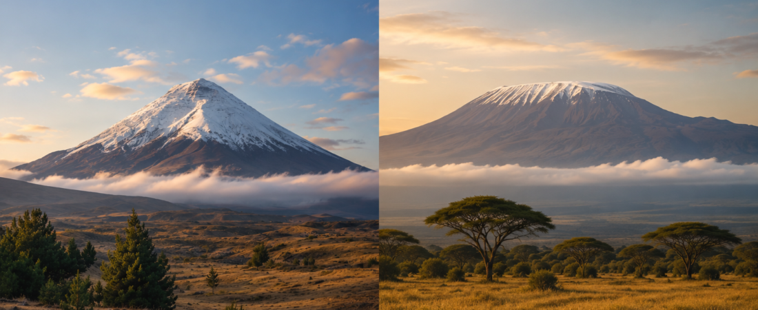
Cotopaxi is steep-sided, compact, and close to symmetrical. Its glacier-covered upper slopes surround a summit containing nested craters. From many viewpoints, the mountain appears as a single cone with one dominant summit.
Kilimanjaro is broader and more varied. Kibo forms its central mass, Mawenzi has a broken, rocky profile, and Shira appears as a wide western shoulder. The massif is therefore experienced less as a single cone than as a group of connected volcanic landforms.
This difference also affects how each mountain is encountered. At Cotopaxi, visitors can travel by road across the páramo and reach the upper slopes quickly. The cone remains visible through much of the visit when weather permits. On Kilimanjaro, the mountain unfolds over several days as climbers pass through forest, heath and moorland, alpine desert, crater terrain, and the summit zone.
Geological activity and natural hazards
Cotopaxi’s eruptive history includes explosive eruptions, ashfall, pyroclastic flows, and lahars. Lahars are especially important because eruptions can melt snow and ice, sending water, mud, and volcanic debris into valleys far beyond the summit. Hazard maps and evacuation planning therefore cover both the mountain and downstream settlements and infrastructure.
This makes volcanic monitoring central to Cotopaxi’s management even during periods of low activity. Access to the upper mountain can be restricted when conditions change, and summit procedures include registration and entry and exit controls.
Kilimanjaro’s principal visitor hazards include altitude illness, cold exposure, exhaustion, falls, and rockfall on some high routes. In January 2006, a rockfall near the Western Breach killed three climbers and injured five, leading to investigations and changes intended to reduce exposure on the route. Fire is also a significant environmental and management threat, particularly in the forest and moorland zones.
Ecology and environmental change
Cotopaxi National Park contains four commonly identified Holdridge life zones: montane rainforest, pluvial páramo, alpine tundra, and a nival zone at the highest elevations. For most visitors, the dominant landscape is open páramo with grassland, wetlands, lagoon margins, volcanic scree, and glacier ice above.
Kilimanjaro contains five widely recognized elevation zones: lower slopes, montane forest, heath and moorland, alpine desert, and the summit. A standard ascent passes through these zones in sequence, making ecological change a conspicuous part of the journey.
Both mountains have experienced substantial glacier retreat. Research on Cotopaxi found significant loss of glacier extent between 1976 and 2013, continuing a longer decline. On Kilimanjaro, approximately 85 per cent of the ice area mapped in 1912 had disappeared by 2011. The surviving ice is now divided into smaller, separated bodies, mainly around Kibo.
Both protected areas also have important hydrological functions. Cotopaxi National Park contains numerous small watersheds, while its páramo soils and vegetation store and regulate water. Kilimanjaro’s montane forest is described by Tanzania National Parks as a water tower for the densely populated surrounding slopes. These functions are important to communities and agriculture beyond the park boundaries.
Access, ascent, and visitor infrastructure
Cotopaxi is unusually accessible for a mountain of 5,897 metres. Visitors can enter the national park by road, stop at sites such as Limpiopungo Lagoon, and continue toward the José Rivas refuge without attempting the summit. This allows the park to serve both day visitors and mountaineers.
The summit ascent is much more demanding than an ordinary park visit. It involves glacier travel, crevasse hazards, severe cold, and rapid exposure to high altitude. Ecuador’s February 2024 progressive-reopening rules required summit groups to obtain a quota, register through the environmental information system, reserve refuge and acclimatization accommodation, and carry suitable equipment. Tourism operators were required to use certified guides, while recognized mountain clubs followed a separate club-leader process. Because these rules can change with volcanic and glacier conditions, they should be cited with their date rather than presented as permanent arrangements.
Kilimanjaro is normally climbed as a multiday trek. Tanzania National Parks describes standard ascents to Kibo as taking approximately five to eight days, depending on the route. Although the normal routes do not usually require technical climbing, the ascent is physically demanding because of its duration, altitude, cold, and cumulative fatigue.
Kilimanjaro has a large and formal visitor system. Climbers enter through designated gates and use fixed routes. Marangu has mountain huts, while other routes rely mainly on designated campsites. Commercial ascents usually involve guides, assistant guides, porters, and cooks, together with park fees, rescue charges, and accommodation or camping fees.
Cotopaxi’s visitor infrastructure is smaller. It includes park entrances, roads, interpretation and day-use sites, the José Rivas refuge, and accommodation such as Tambopaxi. Its summit operation is shorter and more exposed to changes in volcanic activity and glacier conditions. Kilimanjaro, by contrast, supports an extended trekking operation lasting several days.
Cultural and historical significance
Kilimanjaro is Africa’s highest mountain and has been a UNESCO World Heritage property since 1987. It is prominent in Tanzania’s tourism and conservation system and is closely associated with the Chagga communities of its southern and eastern slopes.
Tanzania National Parks identifies Kifinika, on the Marangu route, as a sacred Chagga site historically used for cultural rituals. Wider scholarship also documents Chagga relationships with land, farming, ancestry, and sacred places around the mountain. These associations show that Kilimanjaro is not only a natural landmark or climbing destination.
Cotopaxi has a well-documented place in the history of scientific travel and Andean mountaineering. Alexander von Humboldt attempted to climb it in 1802, and Wilhelm Reiss and Ángel Escobar completed the first recorded summit ascent in 1872. Cotopaxi subsequently appeared in scientific accounts, travel writing, landscape art, and the developing literature of Andean exploration.
Claims about Cotopaxi’s contemporary Indigenous meanings are common in tourism and heritage writing, but they require more careful sourcing from Indigenous or ethnographic scholarship.
History of mapping
Both mountains were known and navigated locally long before they appeared in modern European cartography, but their surviving published maps largely developed through scientific expeditions. Cotopaxi was surveyed by nineteenth-century geologists and explorers including Wilhelm Reiss, Alphons Stübel, and Theodor Wolf; Wolf’s study of the 1877 eruption included a map of the volcano’s surroundings, while later work shifted toward geological and hazard mapping, notably a 1978 reconnaissance hazard map and a 1:50,000 geological map completed after more than twenty years of field research. Kilimanjaro was first represented through expedition sketches, including those associated with Hans Meyer, before Fritz Klute and Eduard Oehler produced the first detailed survey of the entire massif in 1912. Their six-month campaign used ground-based photogrammetry to create a 1:50,000 map; the glaciers were remapped at 1:25,000 in 1953, followed by aerial photography and satellite surveys. Modern mapping of both volcanoes now combines satellite imagery, GPS, drones, and digital elevation models, with Cotopaxi mapping focused particularly on hazards and Kilimanjaro mapping on topography and glacier retreat.
Protection, visitor management, and local economies
Cotopaxi National Park was established in 1975. Older Ecuadorian records give its area as 33,393 hectares, while the July 2026 World Database on Protected Areas reports 328.19 square kilometres. The difference appears to reflect changes in mapping or database updates rather than a different protected-area designation.
Volcanic risk strongly influences the park’s management. Registration, access controls, evacuation planning, route restrictions, and lahar maps are part of normal administration. Tourism is not the park’s only management concern: recent research also identifies grazing, relationships between stakeholders, and the need for greater participation by local communities.
A 2024 carrying-capacity study found that the Limpiopungo trail and the route between the upper parking area and José Rivas refuge exceeded their calculated effective capacities mainly during Ecuadorian national holidays. This suggests concentrated pressure at particular sites and times rather than constant park-wide overcrowding.
Kilimanjaro National Park was established in 1973 and expanded in 2005 to include montane forest that had previously been managed as a forest reserve. This creates an apparent discrepancy in published areas. UNESCO still records a World Heritage property of 75,575 hectares and notes that the enlarged park boundary has not been fully reflected in the World Heritage boundary. Recent Tanzania National Parks material gives the present national park an area of about 1,712 square kilometres.
Kilimanjaro receives roughly 50,000 climbers or park visitors annually, depending on the year and the measure used. It is also one of Tanzania National Parks’ largest sources of revenue, ranking behind Serengeti in recent TANAPA reporting. Tourism pressures include route congestion at busy times, waste, fire, infrastructure demands, climate change, and working conditions in the trekking industry.
The standard Kilimanjaro ascent directly depends on a large local workforce of guides, assistant guides, porters, cooks, drivers, and accommodation staff. Porter pay, equipment, loads, food, and tipping practices remain important labour concerns, and conditions vary between operators.
Tourism around Cotopaxi also supports guides, drivers, accommodation, food services, equestrian activities, and nearby haciendas. It does not, however, revolve around a single large multiday trekking system. Tourism exists alongside agriculture, grazing, and other local land uses.
Social openness
The two destinations differ sharply for gay and other LGBT+ travellers. In Ecuador, same-sex relationships are legal, but official travel advice notes that attitudes can remain conservative outside major cities and that public affection may attract unwanted attention, particularly in small towns; the rural Cotopaxi region is therefore likely to feel less openly LGBT-friendly than central Quito. Tanzania presents a substantially greater legal risk: same-sex sexual activity is criminalized, public displays of affection may lead to harassment or arrest, and authorities have targeted people on the basis of their real or perceived sexual orientation. Moshi and Kilimanjaro’s trekking industry is accustomed to international visitors, but this does not remove that risk. Women face no formal barrier to visiting or climbing either mountain, but official advice for both countries reports verbal harassment and sexual assault risks, especially when travelling alone, at night, or in isolated places. For women and LGBT+ visitors alike, a reputable operator, secure transport and accommodation, vetted guides, and clear procedures for reporting misconduct are important parts of the visitor experience.
Conclusion
Cotopaxi and Kilimanjaro are both high tropical volcanoes with retreating glaciers, protected-area status, and major roles in regional tourism. Their physical form and visitor systems are nevertheless quite different.
Cotopaxi is an active, road-accessible, glacier-covered cone whose management centres on volcanic risk. Kilimanjaro is a dormant, multi-cone massif experienced through a regulated multiday trek across distinct elevation zones and supported by a large guide-and-porter economy.
Selected sources
- Smithsonian Global Volcanism Program: Cotopaxi
- Smithsonian Global Volcanism Program: Kilimanjaro
- Instituto Geofísico: Cotopaxi monitoring, 2026
- Ecuadorian Ministry of Environment: Cotopaxi ascent requirements, February 2024
- UNESCO: Kilimanjaro National Park
- Tanzania National Parks: Kilimanjaro park and facilities
- Tanzania National Parks: Kilimanjaro visitor brochure
- Environmental change in Cotopaxi National Park
- Cotopaxi participatory-planning study
- Cotopaxi visitor carrying-capacity study
- A century of ice retreat on Kilimanjaro
- Protected Planet: Cotopaxi National Park