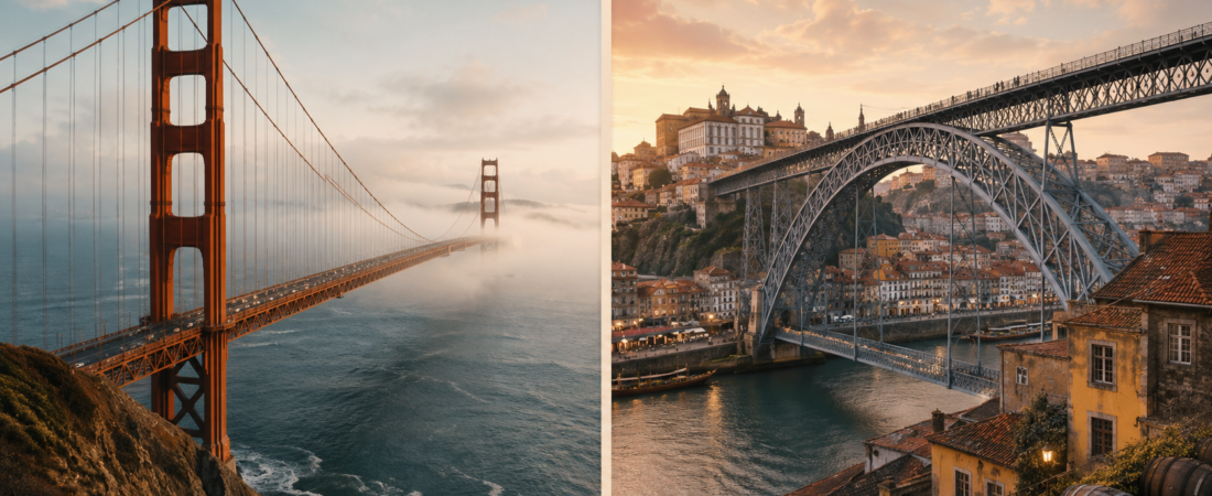
Golden Gate Bridge sits at the mouth of San Francisco Bay, where the water narrows before opening into the Pacific. A visit there is shaped by distance, wind, traffic, salt air and fast changes in visibility. In fog, parts of the bridge can vanish. From close range, the bridge is often too large to take in at once, so many visitors split the visit between the sidewalk, Fort Point, Baker Beach, the Presidio or the Marin Headlands.
Dom Luís I Bridge is not approached in the same way. It stands inside Porto, between steep streets, tiled façades, riverfront terraces and the wine lodges of Gaia. The crossing itself is short, but it changes the view quickly: river below, old town on one side, Gaia on the other, and the Serra do Pilar area above. It is less a separate outing than a piece of Porto’s daily route map.
Comparison matrix
| Criterion | Golden Gate Bridge | Dom Luís I Bridge |
| Geography | Coastal strait between San Francisco and Marin; bay, Pacific, headlands and skyline. | Urban Douro crossing between Porto and Gaia; steep old town, riverfront and wine district. |
| Structure | Suspension bridge opened in 1937; towers, cables, exposed sidewalks and road traffic. | Double-deck metal arch bridge opened in 1886; upper level for metro and pedestrians, lower level for city movement. |
| Scale | 1.7 miles long, 4,200 ft main span, 746 ft towers; difficult to grasp from one close viewpoint. | About 395 m long and 8 m wide; smaller, but strong because river, slope and city sit tightly together. |
| Visit pattern | Usually a planned outing with sidewalk hours, weather checks, parking or bus planning and separate viewpoints. | Usually part of a walk through Porto and Gaia, with metro, viewpoints, cafés, wine lodges and riverfront routes nearby. |
| Comfort issues | Wind, cold, fog, traffic noise, shifting visibility and cyclist-pedestrian tension. | Crowds, height exposure, rain-slick surfaces and photo-stop congestion. |
| Meaning | San Francisco civic symbol and major twentieth-century engineering landmark. | Part of Porto’s UNESCO-listed historic urban landscape and tied to the Douro/Gaia relationship. |
Location and geography
Golden Gate Bridge is a coastal crossing. It links San Francisco with Marin County across the Golden Gate strait, where San Francisco Bay meets the Pacific. The visitor sees water, headlands, fog, skyline and open sky, often with strong wind moving across the deck.
Dom Luís I Bridge crosses the Douro River between Porto and Vila Nova de Gaia. It sits inside the historic city rather than outside it. UNESCO’s listed property includes the Historic Centre of Oporto, Luiz I Bridge and the Monastery of Serra do Pilar, and describes a city shaped by hills, river trade and maritime connections [5]. On foot, the bridge frames Ribeira, Gaia’s wine-cellar district, the steep southern bank and the rooftops of Porto. Its setting is compact, vertical and urban.
Structure and date
Golden Gate Bridge is a suspension bridge, opened in 1937. Its identity comes from two tall towers, long main cables, vertical suspenders and a roadway hung across a marine strait. Official data gives two main towers, each 746 ft above the water, and two main cables. Each cable is 7,650 ft long and contains 27,572 wires. This structure affects the crossing directly. The walk is long, open and repetitive: tower, cable, traffic, water, wind, then more cable and road.
Dom Luís I Bridge is a double-deck metal arch bridge. Infraestruturas de Portugal states that it was built between 1881 and 1886, inaugurated on 31 October 1886, designed by François Gustave Théophile Seyrig, and built to replace an earlier suspension bridge at the same crossing. The two decks create two different uses. The upper level carries metro and pedestrians and gives the high view. The lower level sits closer to the river and carries daily city movement.
Scale and physical presence
Golden Gate Bridge is large enough that it is not easily understood from one position. The official figures explain why: 1.7 miles total length, 4,200 ft main span, 90 ft width, 10 ft sidewalks and 746 ft towers [1]. A visitor usually sees it in parts. From the Welcome Center the bridge reads one way; from Fort Point it reads another; from Baker Beach or the Marin Headlands it becomes part of the whole bay landscape.
Dom Luís I Bridge is much smaller in measured size, but it has a strong presence because Porto is steep and dense. Infraestruturas de Portugal gives the upper level as about 391 m between upper abutments, the lower deck as about 174 m between lower abutments, total structural length around 395 m and width of 8 m [4]. The bridge does not overpower a huge landscape. It pulls the river, slope, streets, façades and viewpoints into one tight view.
Viewpoints
Golden Gate Bridge: choose Hawk Hill / Marin Headlands for the cleanest overall view. It gives elevation, bridge, Pacific coast, bay, skyline and fog context in one frame; recent reporting describes Hawk Hill as a reopened 923-foot viewpoint with sweeping views of the Pacific coast, Golden Gate Bridge and San Francisco skyline. For a closer, more dramatic bridge-only image, Battery Spencer is also a strong option, but Hawk Hill gives the fuller landscape.
Dom Luís I Bridge: choose Serra do Pilar / Jardim do Morro on the Gaia side. Serra do Pilar sits on an outcrop overlooking Dom Luís I Bridge and Porto’s historic centre, while Jardim do Morro is directly by the bridge’s upper level, metro station and Gaia cable-car area. Serra do Pilar is the best viewpoint, and Jardim do Morro is the easiest sunset viewpoint.
Role and movement
Golden Gate Bridge was built as a regional connector, and it still works that way. It links San Francisco and Marin County and carries road traffic, cyclists and pedestrians. San Francisco Travel describes it as a link that brought San Francisco and Marin closer together and as part of the U.S. Route 101 crossing. For a visitor, the road function is hard to ignore. Traffic noise, speed and wind from vehicles sit beside the view.
Dom Luís I Bridge is a city connector between Porto and Vila Nova de Gaia. The official Portuguese infrastructure source describes the upper deck as used by a Metro do Porto line and pedestrians. The lower deck is used by thousands of pedestrians, especially tourists, and also by public transport, taxis and bicycles. A visitor may cross it while moving from the Cathedral area to Jardim do Morro, from Ribeira to Gaia, or from a riverfront meal to a sunset viewpoint.
Practical visit
Golden Gate takes some planning. The official pedestrian and cyclist page says pedestrians use only the east sidewalk during posted hours. Cyclists have toll-free 24-hour access, but sidewalk assignments, closures and rules apply. Scooters, skateboards, rollerblades, roller skates and drones are not allowed on the sidewalks. A simple walk therefore depends on time of day, weather, transport, parking and how much of the bridge the visitor intends to cover.
Golden Gate also has more formal visitor infrastructure. The official visitor page lists a Welcome Center, exhibits, viewpoints and walking tour information. That gives the visit a clear start point and makes it easier to treat the bridge as the main outing. Dom Luís I is more direct for most visitors: walk across, stop for the view, take the metro, descend to Ribeira, continue to Gaia, or climb toward Serra do Pilar.
Access and cost
Golden Gate is free on foot and by bicycle, but it is a tolled vehicle bridge. The official toll page states that tolls are collected only southbound into San Francisco and that all tolling is electronic. Cash is not collected at the bridge. This matters for visitors driving rental cars, because the crossing can involve rental-agency toll handling or later payment. On foot, the cost issue disappears, but sidewalk hours and safety rules still matter.
Dom Luís I is presented in the official infrastructure source as public urban infrastructure used by metro, pedestrians, public transport, taxis and bicycles [4]. The reviewed official material did not show a bridge-specific pedestrian ticket, observation-deck ticket, bridge-climb ticket or opening-hours regime like Golden Gate’s sidewalk rules. That does not mean access can never change because works, events or crowd control can affect public infrastructure. The safe statement is simpler: Dom Luís I functions as a public city crossing rather than a paid bridge attraction.
Public reviews and complaints
For Golden Gate Bridge, visitor comments often separate the view from the conditions around it: people praise the bridge, the bay setting, the walk, the engineering and the nearby viewpoints, but also mention cold wind, fog, traffic noise, busy parking near the visitor area, high souvenir prices and occasional conflict between walkers and cyclists.
Dom Luís I Bridge attracts a different kind of comment. Reviews tend to focus on the upper-deck view over Porto and Gaia, the easy crossing between Ribeira and the wine-cellar side of the river, sunset photographs, night lighting and the fact that the bridge fits naturally into a walk through the city. The weaker points are also specific: crowding at popular hours, people stopping suddenly for photos, discomfort for visitors sensitive to height, and the need to stay aware of metro movement on the upper level.
Weather, comfort and risk
Golden Gate is more exposed to weather and infrastructure risk. Wind, fog, and cold air are normal parts of crossing it, and high winds can affect cyclist access on the sidewalks. Earthquake risk also belongs in the background: San Francisco sits in a highly active seismic region, and the bridge’s long retrofit history reflects that.
Dom Luís I is less exposed to ocean weather and has lower seismic risk than San Francisco, but Porto is not earthquake-free. Its main visitor discomforts are different: height on the upper deck, crowds at busy times, people stopping for photos, metro movement nearby, and rain making surrounding surfaces slippery. Official evidence also points to heavy pedestrian use and vibration-management work linked to large groups.
Noise exposure
Golden Gate Bridge is noisier. The reason is structural and practical: pedestrians are beside a six-lane highway carrying U.S. 101 / CA-1 traffic, and available evidence also points to specific noise issues around the bridge: Highway 101 hum near viewpoints, foghorns, and the documented wind-induced “singing” or humming from bridge elements in strong wind.
Dom Luís I Bridge has many noise sources, but they are more intermittent. The upper deck carries metro and pedestrians; the lower deck carries public transport, taxis, cyclists and pedestrians. That means passing metro noise, crowd noise and some lower-deck vehicle noise.
Protection
Golden Gate Bridge is not part of a UNESCO World Heritage. Its importance is civic, visual and engineering-based. It stands for San Francisco, twentieth-century bridge building, and the drama of crossing between city and headland.
Dom Luís I has formal heritage status through its place in the UNESCO property titled Historic Centre of Oporto, Luiz I Bridge and Monastery of Serra do Pilar.
Curious facts
Golden Gate’s name does not come from its orange colour: it spans the Golden Gate strait, while the “International Orange” paint was chosen later for visibility and fit with the landscape. Its two main cables contain more than 80,000 miles of wire, often described as enough to circle Earth three times. Dom Luís I has its own myth: it is often loosely associated with Eiffel, but the bridge was designed by Théophile Seyrig, Eiffel’s former partner, whose proposal beat Eiffel’s own design in the Porto competition. Its two decks also changed roles over time: the upper level moved from road traffic to metro and pedestrian use, while the lower deck remains the everyday city crossing between Porto and Gaia.
Visitor types
Golden Gate is for visitors who want a bridge to feel like an event: exposed, windy, large, photogenic, and worth building a route around. It suits walkers, cyclists, photographers, engineering-minded travellers, and people who like open landscapes more than dense street life. Dom Luís I is for visitors who want the bridge to sharpen the city around them: Porto on one side, Gaia on the other, the Douro below, wine lodges, viewpoints, metro, cafés and old streets within minutes. It suits urban wanderers, first-time Porto visitors, sunset watchers, casual photographers, and travellers who prefer a short crossing with a lot around it.
Sources
- Golden Gate Bridge Highway and Transportation District — design and construction statistics for Golden Gate Bridge.
- Golden Gate Bridge Highway and Transportation District — pedestrian and bicycle access rules.
- Golden Gate Bridge Highway and Transportation District — visiting the bridge, Welcome Center, exhibits and viewpoints.
- Golden Gate Bridge Highway and Transportation District — tolls and vehicle-payment rules.
- San Francisco Travel — Golden Gate Bridge visitor guide, viewpoints, history and visitor context.
- National Park Service / Golden Gate National Recreation Area — surrounding parks, trails, Fort Point, Presidio and Marin Headlands context.
- Infraestruturas de Portugal — official Ponte Luiz I / Dom Luís I Bridge page: structure, dates, dimensions, decks, use and rehabilitation notes.
- UNESCO World Heritage Centre — Historic Centre of Oporto, Luiz I Bridge and Monastery of Serra do Pilar.
- VisitPortugal — Porto visitor context: historic centre, Douro, Gaia, wine lodges and surrounding tourism ecosystem.
- Metro do Porto — upper-deck transit context for Dom Luís I Bridge.
- Tripadvisor — visitor reviews for Golden Gate Bridge and Dom Luís I Bridge.
- Google Maps reviews — visitor-review patterns, ratings, crowd comments, photo behaviour and practical complaints for both bridges.