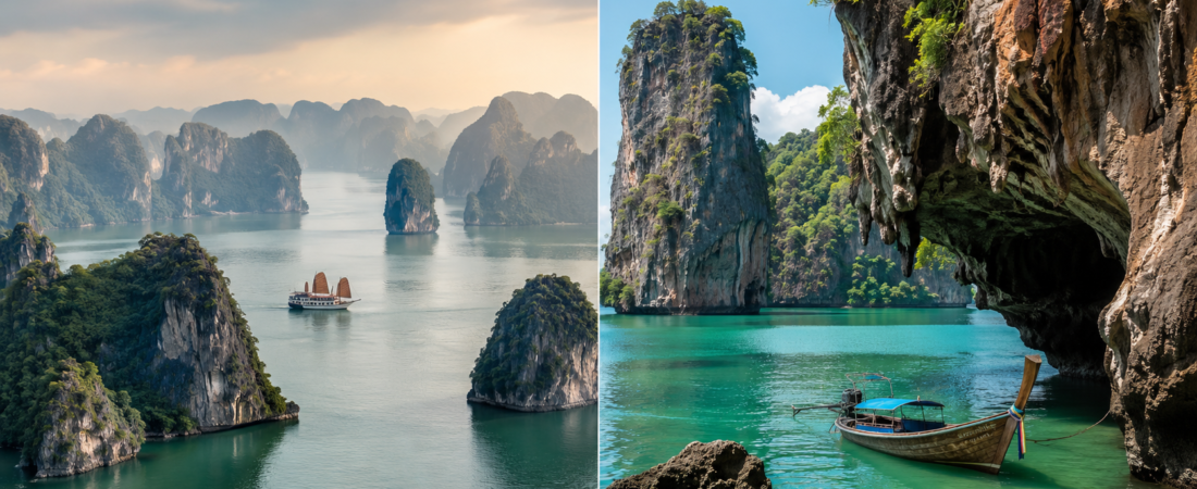
Ha Long Bay is a large northern Vietnam seascape organised around cruise infrastructure, wide karst repetition and UNESCO heritage framing. Phang Nga Bay is a compact Andaman marine-park route shaped by caves, hongs, mangrove channels, canoe segments and a few concentrated stops such as Khao Phing Kan/Ko Tapu and Ko Panyi.
Snapshot
| Dimension | Ha Long Bay | Phang Nga Bay |
| Trip role | Often a northern Vietnam anchor from Hanoi, Ha Long City, Tuan Chau or Cat Ba. | Usually a one-day Andaman excursion from Phuket, Khao Lak, Krabi or Phang Nga. |
| Spatial feel | Large field of limestone towers, cruise lanes, islands, caves and wide water gaps. | Compact sequence of cliffs, caves, hongs, mangroves, villages and photo stops. |
| Movement | Cruise-led: deck time, meals, cabins on overnight products, short activity stops. | Boat-and-canoe-led: longtail or speedboat transfers, cave mouths, lagoons and wet landings. |
| Strongest visual logic | Layered silhouettes and broad panoramas; the image builds through repetition. | Close-range frames, cave openings, vertical rock faces, mangrove corridors and Ko Tapu. |
| Main pressure points | Cruise traffic, port logistics, variable boat quality, cave queues, weather visibility. | Speedboat noise, tour clustering, James Bond Island congestion, tide and monsoon constraints. |
| Weakest fit | Travellers who dislike cruise packaging, fixed schedules or large tourism infrastructure. | Travellers seeking long quiet immersion, low heat exposure or routes without packaged stops. |
Location and geographic setting
Ha Long Bay lies in northeastern Vietnam, in the Gulf of Tonkin, within the Quang Ninh and Hai Phong/Cat Ba setting. UNESCO describes the Ha Long Bay – Cat Ba Archipelago property as covering 65,650 hectares and including 1,133 islands and islets. That scale makes the bay feel like a destination zone rather than a single excursion: ports, cruise terminals, hotels, roads, day boats, overnight boats and nearby Cat Ba all shape the trip.
Phang Nga Bay sits on Thailand’s Andaman side, off Phang Nga Province and within reach of Phuket, Khao Lak, Krabi and Phang Nga town. Ao Phang Nga National Park is commonly described as a roughly 400-square-kilometre marine national park created in 1981. Its visitor geography is less like a self-contained resort bay and more like a protected seascape inserted into the wider Phuket-Andaman holiday economy.
The travel difference is immediate. Ha Long usually requires a deliberate transfer and at least a full-day commitment; an overnight cruise changes the rhythm even more. Phang Nga can be added to an Andaman itinerary without moving base. That convenience is useful, but it also pushes the bay toward standardised day-tour circuits.
Geological identity and visual form
Ha Long’s strongest factual identity is marine-invaded tower karst. UNESCO frames the extended Ha Long Bay – Cat Ba Archipelago property as one of the world’s most extensive examples of this type, with fengcong clusters, fenglin towers, caves, marine notches and limestone islands rising from the sea. The visual system is cumulative: tower after tower, repeated forms, forested tops, grey-green water and long lateral views.
Phang Nga is also limestone karst, but the form is read at closer range. The bay is associated with steep limestone islands, sea caves, collapsed cave systems, hongs, shallow waters and mangrove channels. The result is more enclosed. Instead of reading the landscape mainly as a field of towers, the traveller moves through passages, under cave mouths, along cliff walls and into small internal lagoons when tides and tour routing allow.
Scale, layout and spatial hierarchy
Ha Long is the more spatially layered system. The traveller is dealing with the bay, Cat Ba, cruise ports, cave stops, viewpoint islands, beaches, floating-village narratives and a large service economy. The hierarchy is broad: base city, port, route, boat, cave, lookout, cabin. A poor itinerary can flatten that scale into a predictable cruise lane, but the underlying geography remains large.
Phang Nga is smaller in area and more compressed in mainstream use. Typical routes concentrate around Khao Phing Kan/Ko Tapu, Ko Panyi, Panak Island, Hong Island, mangrove channels, canoe caves and small beaches. The hierarchy is simpler: pier, transfer, set-piece island, canoe segment, village lunch, return. That clarity helps travellers with limited time, but it can also make the route feel over-processed.
The main risk in Ha Long is dilution: too much infrastructure around too much landscape. The main risk in Phang Nga is compression: too many boats converging on the same few photogenic or easily sellable stops.
Role, historical narrative and cultural identity
Ha Long has a heavier national-heritage role. Its name is tied to the Vietnamese descending-dragon legend, and the wider Ha Long-Cat Ba landscape is now carried by UNESCO recognition, national scenic-site status, conservation language and northern Vietnam itinerary culture. The story is not only geological; it is also a story of Vietnam presenting a national seascape to domestic and international visitors.
Phang Nga’s public identity is more mixed. It is a Thai marine national park and a mangrove-and-karst environment, but mainstream tourism often narrows it to three familiar elements: James Bond Island, sea canoeing and Ko Panyi. Ko Panyi adds a real settlement layer through its Muslim fishing-village history and stilt-built fabric, though day tours can reduce it to a lunch-and-souvenir stop.
Ha Long is presented as heritage landscape first, then cruise product. Phang Nga is presented as marine excursion first, then national park, film location and village stop. That distinction affects the traveller’s attention: Ha Long asks for a slower reading of a large protected seascape; Phang Nga gives more immediate episodes.
Boat route and activity experience
Ha Long tourism is cruise-centred. Products range from half-day and day cruises to overnight routes, usually with fixed meal times and scheduled stops. Common elements include cave visits such as Sung Sot, viewpoint or beach stops such as Titop, kayaking around sheltered areas such as Luon Cave, and deck time between limestone islands. The experience can be comfortable, but it is highly dependent on operator quality and route choice.
Phang Nga tourism is usually day-route-centred. Travellers move by longtail boat, speedboat or larger tour boat, then often switch into canoes for caves, hongs or mangrove sections. Common stops include Khao Phing Kan/Ko Tapu, Ko Panyi, Panak or Hong Island and shallow channels. The route has more tactile variety: boarding, changing craft, ducking under cave ceilings, floating beside mangrove roots, stepping onto village walkways or sand.
Ha Long suits a traveller who accepts cruise structure in exchange for longer time on the water. Phang Nga suits a traveller who wants a more active day without committing to an overnight boat. Neither format is automatically quiet. The difference is where the friction appears: in Ha Long it is scheduling and cruise clustering; in Phang Nga it is transfers, tide timing, heat, speedboat exposure and crowded stopovers.
Viewpoints and photographic logic
Ha Long’s strongest compositions are wide. Boat decks, upper cruise decks and island lookouts show the repeated karst silhouettes in layers. Titop Island is one of the established lookout stops, though it can be busy when multiple boats arrive. Mist, haze or grey winter light can help the bay visually; poor visibility can also make the trip feel flat if the route stays in busy channels.
Phang Nga’s strongest compositions are framed and close. Ko Tapu works as a single subject, cave mouths produce dark-to-light frames, canoe routes make the cliffs feel taller, and Samet Nangshe viewpoint gives the larger mainland panorama back across the bay.
The drawback follows the logic. Ha Long can be hard to photograph cleanly because other boats, haze and cruise traffic enter the frame. Phang Nga can be visually clear but crowded at the exact points where every tour wants the same image.
Local economic impact and tourism ecosystem
Ha Long is tied to a large provincial tourism economy. Cruise fleets, terminals, hotels, road transfers, restaurants, guide services, entertainment complexes and real-estate development all sit around the bay. This creates convenience and capacity, but it also makes the traveller aware of the machinery around the landscape. The bay is not a remote nature escape; it is a heavily serviced heritage destination.
Phang Nga’s economy is more distributed. Revenue passes through Phuket, Krabi, Khao Lak, Phang Nga piers, boat operators, canoe teams, national-park fees, Ko Panyi restaurants and island vendors. The visitor may sleep far outside the bay and consume the place through a tour operator rather than through a dedicated bayfront stay.
Visitor access, cost, safety and social openness
Ha Long is commonly reached by road transfer from Hanoi or by staying in Ha Long City, Tuan Chau or Cat Ba. The base cost depends on transport, route fees, boat class, duration, cabin quality and whether the trip is private, shared, day-only or overnight. A cheap product can be crowded and rushed; an expensive product does not remove weather risk or route congestion.
Phang Nga is easier to add from existing Andaman bases. Phuket, Khao Lak, Krabi and Phang Nga town all feed day tours into the bay. Costs usually bundle transport, boat, lunch, canoeing and national-park fees, but inclusions vary. The cheapest versions tend to increase group size and reduce control over timing.
Safety depends less on the name of the bay than on operator standards and conditions on the day. In Ha Long, check life jackets, boat condition, weather policy, transfer boats, cave stairs and cancellation terms. In Phang Nga, check speedboat exposure, longtail comfort, cave/tide timing, wet landings, canoe procedures and monsoon-season flexibility.
For LGBTQ+ travellers, the difference is mainly national rather than site-specific. Thailand now gives Phang Nga Bay the stronger legal and symbolic backdrop: same-sex marriage has been legal since January 2025, although transgender legal recognition and some family-law details remain unresolved. Vietnam is not comparable legally: same-sex couples can travel openly in mainstream tourist areas, and public attitudes have moved in a more accepting direction, but same-sex marriage and civil unions still lack legal recognition.
Accessibility is the more concrete concern. Cave stairs, small-boat transfers, uneven piers, slippery surfaces, canoe entry and wet landings can limit disabled travellers or anyone with balance, fatigue, heat or sensory sensitivities. Families are common on both routes, but the day can be long, noisy and exposed.
Heritage status, conservation and site management
Ha Long Bay – Cat Ba Archipelago carries UNESCO World Heritage status. Ha Long was first recognised in 1994 and 2000, and the Cat Ba extension was added through a significant boundary modification in 2023. UNESCO’s management text also points to the challenge of tourism levels, cruise regulation, waste discharge and development control. Reuters reported in 2024 that UNESCO planned to assess development risks around Ha Long Bay, reflecting concern over coastal and tourism projects.
Phang Nga Bay is not a UNESCO World Heritage Site. Its protected status is mainly national and ecological: much of the bay falls within Ao Phang Nga National Park, and the bay is also associated with Ramsar wetland protection. The bay is also significant for mangroves, shallow marine habitats and wetland values; the broader Phang Nga Bay Marine National Park is listed in Ramsar material. Park status gives the place a conservation frame, but mainstream visitor experience is still channelled through tour circuits and high-demand stops.
Formal protection does not remove pressure. Ha Long faces cruise traffic, coastal development, waste and landscape-integrity concerns. Phang Nga faces boat concentration, disturbance around caves and mangroves, litter risk and the commercial narrowing of the route to a few stops. The management problem in both cases is not attracting visitors; it is keeping volume, infrastructure and behaviour within the capacity of the seascape.
Natural hazards, climate and environmental risk
Ha Long has a northern Vietnam monsoon pattern. Winter can be cool, grey and misty; summer is hotter, wetter and more humid. Storms or tropical systems can disrupt boats, and visibility can change the whole tone of the trip. A traveller expecting constant tropical brightness may find Ha Long subdued in winter and unstable in wet months.
Phang Nga sits in the tropical Andaman monsoon zone. Heat is more consistent, and the southwest monsoon from roughly May to October brings rain, wind and rougher sea conditions. Some Andaman routes and marine services adjust seasonally; current park notices and operator policies should be checked close to travel because public information on access restrictions can change.
Soundscape, noise, and sensory atmosphere
Ha Long is strongest when the route creates distance from cruise clusters: slow water movement, layers of limestone, low cloud, open decks and long gaps between stops. Its weakest version is port-to-port traffic, engine noise, loud groups, party-cruise sound systems and crowded cave queues. The emotional register is scale, repetition and slow unfolding when the itinerary is well chosen.
Phang Nga is strongest when the engine drops and the route enters mangrove channels, cave mouths or hongs. The canoe-level perspective changes the scale of the cliffs; the water becomes narrower, the rock closer, and the sense of enclosure more immediate. Its weakest version is the overworked James Bond Island stop: queues, souvenir pressure, heat, engines and the same fixed camera angle repeated by several groups.
Noise-sensitive travellers should treat both places carefully. Ha Long requires operator and route selection. Phang Nga requires timing, boat type and group-size control. Calm is possible, but it is not the default output of the mass-tour version of either bay.
Traveller types and visit suitability
Ha Long suits travellers building a northern Vietnam route around Hanoi, Ninh Binh, Cat Ba or Quang Ninh; travellers who want an overnight boat structure; families or older travellers who prefer seated cruise time and organised meals; photographers who want wide karst layering; and travellers willing to pay for route quality rather than only for the lowest advertised cruise price.
Ha Long is weaker for travellers who dislike cruise packaging, port logistics, fixed dining schedules, clustered boats or heavy tourism infrastructure. It can also be hard for travellers with serious mobility limitations if the route includes cave stairs, island climbs, small transfer boats or steep gangways.
Phang Nga suits travellers already based on Thailand’s Andaman side; travellers with only one full day; travellers interested in sea caves, hongs, mangroves and canoe-level views; and those who prefer activity over overnight cruise structure. It also works for travellers who want a recognisable set of scenes without changing accommodation base.
Phang Nga is weaker for travellers seeking long quiet immersion, those highly sensitive to speedboat noise or heat, and mobility-sensitive travellers who may struggle with canoe entry, wet landings, uneven village walkways or boat changes. The route can be rewarding, but the standard day-tour format is not subtle.
Traveller fit matrix
| Traveller group | Ha Long Bay | Phang Nga Bay |
| First-time regional travellers | Strong fit for travellers who want northern Vietnam’s limestone seascape, UNESCO framing, cruise decks, caves and broad bay views in one structured experience. | Strong fit for travellers already on Thailand’s Andaman coast who want cliffs, lagoons, mangroves, island stops and canoe passages without a long inland transfer. |
| Short-stay travellers | Less efficient unless already near Ha Long, Cát Bà or Hải Phòng; the Hanoi transfer can make a same-day visit feel over-compressed. | Easier to fit into a beach-holiday itinerary from Phuket, Khao Lak, Krabi or Phang Nga as a one-day excursion. |
| Photography-focused travellers | Works for layered horizons, mist, limestone silhouettes, deck compositions and elevated bay viewpoints; weaker when haze, cruise density or dock clutter dominate. | Works for tighter compositions: cave mouths, mangrove channels, canoe passages, Ko Tapu and Samet Nangshe-style viewpoints; weaker at crowded set-piece stops. |
| Families | More predictable when using a stable cruise product with fixed meals, toilets and scheduled stops; long transfers and crowded caves can tire children. | More varied and active, with canoes, short island stops and changing scenery; heat, speedboat motion and boat transfers need planning. |
| Culture-and-context travellers | Stronger heritage narrative: dragon legend, fishing communities, UNESCO status, conservation pressure and the cruise economy around Ha Long and Cát Bà. | More mixed cultural frame: marine national park, Ko Panyi village stop, Andaman Muslim community context, James Bond film memory and Phuket-driven tour economy. |
| Quiet / sensory-sensitive travellers | Requires careful cruise choice: smaller boats, non-party products, off-peak departures and routes away from the busiest cave stops. | Can feel calm in canoe sections and early routes, but speedboats, engine noise and peak-hour clustering around James Bond Island can be harsh. |
| LGBTQ+ travellers | Mainstream tourist setting with no strong site-level exclusion evidence found, but Vietnam does not legally recognise same-sex marriage or civil unions. | Mainstream tourist setting with no strong site-level exclusion evidence found, and Thailand now gives travellers a stronger national legal backdrop through same-sex marriage recognition. |
| Reduced-mobility / fatigue-sensitive travellers | The more structured cruise format can help, but gangways, stairs, cave routes, uneven piers and tender transfers remain serious constraints. | More physically unpredictable because many tours involve small boats, canoes, wet landings, uneven island surfaces, heat and tide-dependent movement. |
| Travellers wanting a controlled itinerary | More suitable for travellers who want fixed routing, meals, overnight options and fewer decisions once the trip starts. | Less controlled: experience quality depends heavily on operator, boat type, tide timing, crowd timing and weather. |
| Active water-experience travellers | Activity exists, but the dominant rhythm is cruise-based sightseeing, cave stops and deck viewing. | Stronger fit for travellers who want canoeing, close passage through limestone formations, mangrove channels and more direct water-level movement. |
Conclusion
Ha Long Bay is the larger heritage seascape: broad marine-invaded tower karst, heavier cruise infrastructure, stronger UNESCO framing and a rhythm that usually needs a full day or overnight to make sense. Phang Nga Bay is the more compact Andaman marine-park route: caves, hongs, mangroves, canoe-level movement and concentrated day-tour stops. Ha Long asks the traveller to manage cruise quality and scale; Phang Nga asks the traveller to manage timing, group size, heat, noise and the compression of the standard route.
Sources
- UNESCO World Heritage Centre — Ha Long Bay – Cat Ba Archipelago: area, island count, World Heritage status, marine-invaded tower karst, management and conservation notes. https://whc.unesco.org/en/list/672/
- Reuters — UNESCO to study development risks to Vietnam’s Ha Long Bay, 20 Dec 2024: development-risk context. https://www.reuters.com/world/asia-pacific/unesco-study-development-risks-vietnams-ha-long-bay-2024-12-20/
- Vietnam.travel — Ha Long Bay visitor information: destination context, access and common visitor framing. https://www.vietnam.travel/places-to-go/northern-vietnam/ha-long-bay
- Tourism Authority of Thailand — Phang Nga destination information: provincial access, Andaman context and tourism framing. https://www.tourismthailand.org/Destinations/Provinces/Phang-Nga/352
- Thailand Department of National Parks / Ao Phang Nga National Park public information: national-park status, area, attractions and seasonal notices. Public access pages can change; current notices should be checked before booking.
- Ramsar Sites Information Service — Phang Nga Bay Marine National Park: wetland and mangrove context. https://rsis.ramsar.org/ris/1185
- Lonely Planet guide material for Ha Long Bay, Phang Nga Bay, Phuket, Krabi and nearby access bases: visitor-route context and guidebook framing.
- Google Maps public review sampling: Ha Long Bay, Tuan Chau harbour, Ao Phang Nga National Park, Khao Phing Kan/Ko Tapu, Ko Panyi and Samet Nangshe viewpoint.
- Tripadvisor public review sampling: Ha Long Bay cruises, Phang Nga Bay, James Bond Island, Ko Panyi and sea-canoe tours.
- Climate and weather references checked for northern Vietnam / Ha Long and Thailand’s Andaman coast / Phang Nga: seasonal rain, heat, winter haze and monsoon exposure.